Russia Faked MH17 Images

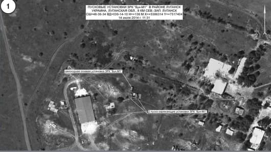
Satellite images delivered to the press by Russian Defense Ministry.
Russian authorities doctored satellite images it used to try peg the downing of Malaysia Airlines flight MH17 on Ukraine, an independent report has claimed.
Investigative journalism site Bellingcat claimed that a Russian Ministry of Defence (MOD) press conference on July 21 2014 of the downing of the Amsterdam-Kuala Lumpur flight on July 17 had presented deliberately misleading information.
Authorities at the time presented satellite images that they claimed showed Ukrainian Buk surface-to-air missile launchers were active and within firing range of the plane on the day it was downed.
Bellingcat's team analyzed image content and soil structures through publicly sourced Google Earth images and concluded that Russia tried to pass June photos as ones from July.
"The Russian Ministry of Defence presented digitally modified and falsely dated satellite images to the international public in order to implicate the Ukrainian army in the downing of MH17," the report said.
Malaysia Airlines' flight MH17 killed at 298 people on board when it crashed near the Russian border near Ukraine on July 17, 2014, two thirds of which were Dutch Nationals.
Nick de Larrinaga, Europe Editor, IHS Jane's Defence Weekly told CNBC that it's "absolutely possible" that Russia doctored their evidence and said Bellingcat's report hardly seems far-fetched.
CNBC:


